


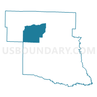
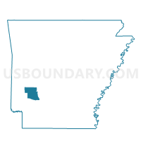
Daisy Voting District, Pike County, Arkansas
About
Outline

Summary
| Unique Area Identifier | 527629 |
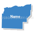
| Name | Daisy Voting District |
| County | Pike County |
| State | Arkansas |
| Area (square miles) | 45.54 |
| Land Area (square miles) | 39.15 |
| Water Area (square miles) | 6.39 |
| % of Land Area | 85.97 |
| % of Water Area | 14.03 |
| Latitude of the Internal Point | 34.23365100 |
| Longtitude of the Internal Point | -93.75145950 |
Maps

Graphs
Select a template below for downloading or customizing gragh for Daisy Voting District, Pike County, Arkansas


Neighbors
Neighoring Voting District (by Name) Neighboring Voting District on the Map
- Kirby Voting District, Pike County, AR
- Langley/Lodi Voting District, Pike County, AR
- MUDDY FORK Voting District, Howard County, AR
- Murfreesboro North Voting District, Pike County, AR
- Murfreesboro West 1 Voting District, Pike County, AR
- Murfreesboro West 2 Voting District, Pike County, AR
- New Hope Voting District, Pike County, AR
Top 10 Neighboring County Subdivision (by Population) Neighboring County Subdivision on the Map
- Thompson township, Pike County, AR (2,424)
- Antoine township, Pike County, AR (826)
- Self Creek township, Pike County, AR (685)
- White township, Pike County, AR (618)
- Muddy Fork township, Pike County, AR (249)
- Muddy Fork township, Howard County, AR (132)
Top 10 Neighboring Place (by Population) Neighboring Place on the Map
Top 10 Neighboring Unified School District (by Population) Neighboring Unified School District on the Map
- Murfreesboro School District, AR (3,183)
- Dierks School District, AR (2,915)
- Kirby School District, AR (2,910)